| District Profile |
|
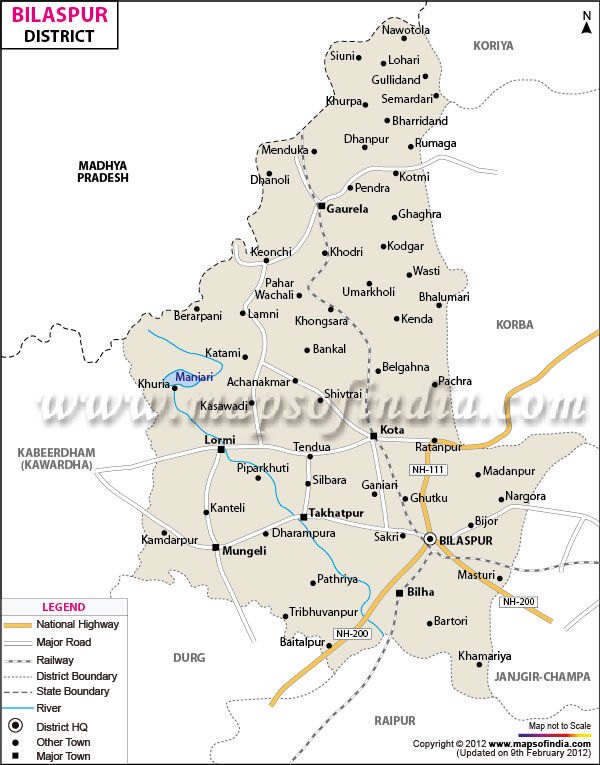
Bilaspur District is situated in the eastern part of the newly formed Chhattisgarh state within the Indian union. It is about 400 years old and named after a Fisher-Woman "Bilasa". At present the city is extended in 29.85 sq. km. Having population around 2,74,048. Bilaspur city is on the bank of river Arpa, situated between 21º37"N to 23º07"N Latitude and 81º12"E to 83º40"E Longitude. The average rain fall is 1085.50 mm. and the maximum temperature goes up to 45.40 C. Bilaspur district is surrounded by Koria District in north, ShahdolDistrict of Madhya PradeshMungeli District in West,Balauda Bazar-Bhata Para District in south and Korba Janjgir-Champa District in east. |
||||||||||||||||
|
||||||||||||||||
|
||||||||||||||||
|
|
||||||||||||||||
The general slope of the district is towards the north-east in which direction the major streams of the district flow. |
||||||||||||||||
Arpa
Bilaspur is situated on the banks of the rain-fed Arpa River, which originates from the high hills of the Maikal Range of central India. |
||||||||||||||||
|
|
||||||||||||||||
|
Mineral Resources |
||||||||||||||||
This dolomite rich region is surrounded by lush green forests in the north and the coal mines of Hasdeo valley in the east. |
||||||||||||||||
|
|
||||||||||||||||
|
Climate |
||||||||||||||||
Bilaspur falls within the temperate zone of Indian sub continent. The winter Commences from December and last till the end of February. The summer continues till the second week of June. Monsoon commences from middle of June and remains till the end of September. Excessive heat during summer necessitates general public sleeping in open. The maximum temperature in May 460C and mean minimum temperature is 90c to 70c in December. May is the hottest month & December is the coldest. The relative humidity is higher during the South West monsoon season, being generally over 75%. After Monsoon Season, humidity decreases and during the winter season, air is fairly dry. Rainfall observations indicate that annual rainfall in the area is around 1400 mm. Rains are predominant during July -August. South-West is the predominant wind direction during the period from May to September. Wind is generally calm and the city has around 90 calm days. The layer of soil is moderate and the underground water is sufficient. |
||||||||||||||||
|
|
||||||||||||||||
|
Source of Irrigation & Crops
| ||||||||||||||||
|
The means of irrigation available in the district are Wells, Ponds, Debris, Tube-Wells, Rivers, Nalas, and Canals etc. Paddy, Red Gram, Green Gram, Groundnut and Sesamum are the main crops in Kharif while Wheat, Maize, Gram, Lentils, Blackgram etc. are grown in Rabi season. |
||||||||||||||||
|
|
||||||||||||||||
|
Population of District
| ||||||||||||||||
|
||||||||||||||||
|
|